By Mike Lednovich
Fernandina Beach City Commissioners will see a “Waterfront Resiliency System” conceptual design that is intended to prevent riverfront area flooding but has huge gaps in the wall system — gaps that will allow floodwaters to breach the line.
Kimley-Horne, the firm contracted to do the floodwall design, will present its concept plan at Tuesday’s city commission workshop.
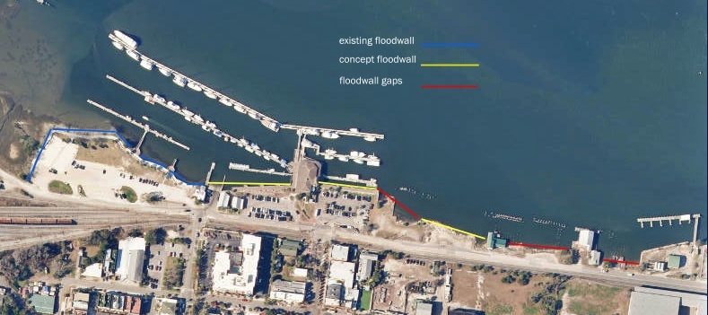
The design is for a floodwall system for segments three through five, from the Atlantic Seafood building running all the way north to property owned by Front Street Property LLC adjacent to the city-owned tract that was acquired in 2016.
There are two major gaps in the concept design. The first is the parcel adjacent to the city parking lot next to Brett’s Waterway Cafe, which is owned by O’Steen Company LLP. The city has been unsuccessful in attempts to acquire the property or obtain a right-of-way in order to include that section in the riverfront protection plan. That means there’s a 95-foot wide opening for floodwaters to flow into downtown.
The second gap in the system is from the Front Street Property parcel, north to the Port Fernandina. That gap is roughly 450 feet.
The lowest points along the river include the O’Steen tract and the city-owned property adjacent to the north at 101 N. Front St. This is the area that floods most often during storms and heavy rains.
“I’m astounded, this is crazy. You don’t have anything, you’re wasting your time to build this,” said Dr. Frank Hopf, a coastal flood and dune expert. “This plan would slow floodwaters in some areas but speed up flooding in the gap areas. It’s the wind tunnel effect of the same amount of water pouring through a smaller space. The water is accelerated by about double.”
In discussing the O’Steen property situation, Commissioner Chip Ross stated in 2022, “This area is the lynchpin of the plan; if we don’t do something here, there is really no point in doing anything else. It’s the lowest point, and it’s already flooding. The railroad tracks and Front Street also flood.”
The city commission had authorized the city to proceed with eminent domain action after years of attempting to purchase the land from an unwilling seller. However, the FBCC abandoned that effort in 2021 as legal fees mounted and the owner-commissioned appraisal exceeded $2 million.
Hopf said the properties just east of the O’Steen property — the Salty Pelican and the Standard Marine building — would receive the brunt of floodwater damage.
“There’s double the amount of erosion taking place with water rushing in and then again when the water recedes,” Hopf said. “It’s not a good outcome for those areas.”
Hopf said the bigger gap to the north is less problematic because the elevation of the riverbank is higher.
Gaps in the wall plan may also allow water to flow through the openings and cause flooding behind the existing walls. This can increase the pressure applied on those walls and make them more vulnerable to failure.
“Again, it’s astonishing the city would even consider wasting money on this,” Hopf said.
The city made some progress on the seawall project last year with the completion of a quarter-mile stretch of the seawall and riverwalk between the city boat ramp at the foot of Ash Street and the southern limits of the city’s parking lot property.
Kimley-Horne is designing the project under a grant through the Florida Inland Navigation District of almost $1 million. But there is no money – estimated at $12 million to $15 million — in the city coffers to pay for construction of the floodwall. Mayor Bradley Bean is a proponent of a bond referendum to pay for the project.


Do this right or forget it. We’ve see what happens with high winds coinciding with extreme flood tides. A misleading waste of money and a waste of common sense until the waterfront flood protection plan can be fully implemented. https://youtu.be/pIa7ymaK2Ko, https://www.news4jax.com/…/fernandina-beach-marina…/, https://ameliaislandliving.com/…/marina-news…/
This is why I resigned from the CRAAB. The city adopted a development plan for the riverfront when it created the CRA in 2005. Practically nothing has been done since then because the flooding must be stopped before anything else can be accomplished, the O’Steen property is the key to that, and the city has been unwilling to use eminent domain. Until the city commission changes its mind on that subject, everything else is a waste of time and money. It also appeared to me that no one with the city government knew anything about eminent domain which is evidenced by the city backing away when O’Steen proffered a $2 million appraisal. Anyone who’s experienced at eminent domain knows that the property owner getting a wildly high appraisal is standard operating procedure. The real negotiation doesn’t begin until the government files the petition with the court. Also, the city doesn’t need to acquire the entire parcel, only enough to build and maintain the seawall. Hopf is correct. The idea of building a partial wall is “crazy.”
Interesting article…..in a June 16, 2021 article by Suanne Thamm, she details the “reversal” of efforts to pursue eminent domain. Ross voted against that reversal……voting FOR it in a 4-1 vote were Bean, Sturges, Vice Mayor Kreger and the Mayor, and author of this article, Lednovich!
That probably should have been a 3-2 vote to continue the action with Lednovich and Kreger voting with Ross……but, for whatever reason, it wasn’t.