By Cindy Jackson
Reporter
October 31, 2021
Gerrymandering is “the manipulation of an electoral constituency’s boundaries so as to favor one party or class.”
On the contrary, unlike gerrymandering, redistricting is based on population growth and other factors not political whim.
Update: To view three redistrict map options, click here.
As outlined on the County website and as articulated at three public meetings recently held throughout Nassau, “the primary and overarching intent of the electoral redistricting process is to create districts that ensure all residents across Nassau County are equitably represented and provide confidence their voices will be heard through the ballot box.”
The Preliminary Electoral Redistricting Report, prepared by the Government Services Group, Inc., (the company County partnered with for establishing the processes for the distribution of CARES Act monies), explains most succinctly, “the U.S. Constitution provides that a population census be conducted every ten years. This census data is used to apportion Congressional seats and allocate federal funding to the States. Within the State of Florida, updated census data is used as the basis to draw congressional district boundaries and state legislative districts.” Plain and simple.
The report goes on to explain that for Nassau County, the governing body is the Board of County Commissioners and the configuration of county commission districts is guided by the Florida Constitution and Florida Statutes.
One of the statutory requirements states that “[t]he Board of County Commissioners shall from time to time, fix the boundaries of the above districts so as to keep them as nearly equal in proportion to population as possible.
One expression commonly used to describe redistricting is “one man, one vote,” a term perhaps most associated with a Supreme Court ruling from 1964 as part of the Reynolds v. Sims case, that said, as summarized, districts for the United States House of Representatives and for districts of both houses of state legislatures must contain roughly equal populations.

Here it is 2021. According to the Bureau of Economic Business and Research (BEBR), between 2019-2020, Nassau County grew by an extraordinary rate of 4.92% — making it the 4th fastest growing County in the State of Florida. As a county with a population of 80,000 or more, Nassau County ranks second.
Over the coming decade (2020-2030), the BEBR predicts Nassau’s population will expand by 36%. The result: over 121,600 people will call Nassau County home by 2030.
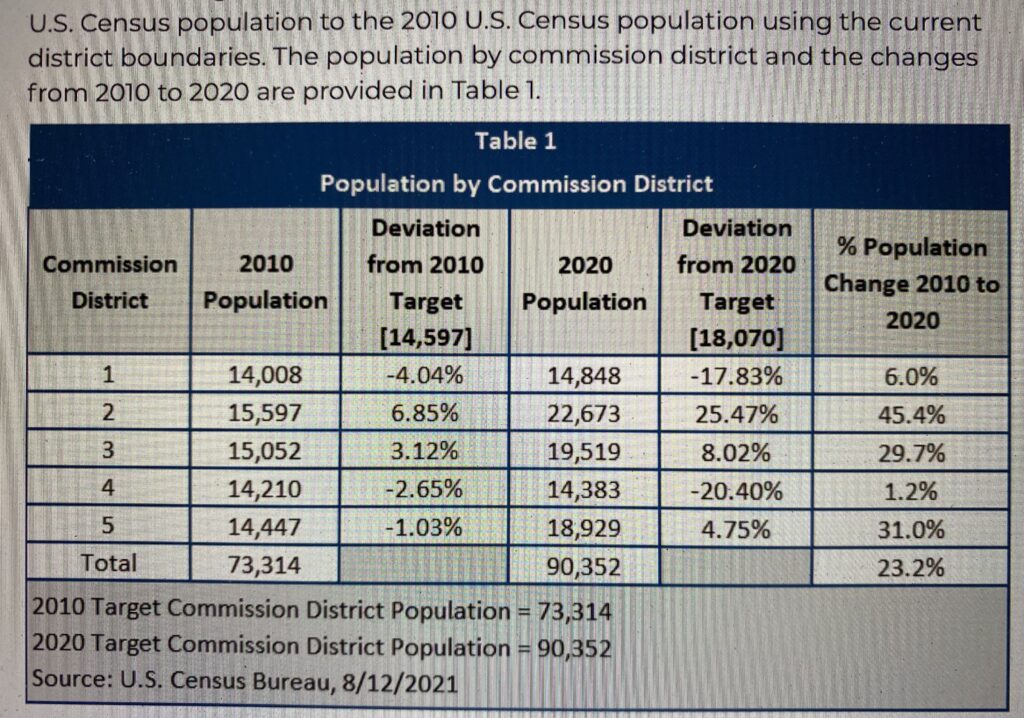
Since the last census (2010) Nassau County has grown by 23.2% . . . with the most growth occurring in District 2 (South Amelia Island, Nassauville and O’Neil, currently represented by Commissioner Bell) and lowest growth rate was experienced in District 4 (Hilliard, Bryceville, Boulougne, Kings Ferry and Nassau Oaks) currently represented by BOCC Chair, Thomas Ford.
Based on the principle of “one man one vote” and using 2020 census data alone, each district would contain 18,070 residents. That number is routinely referred to as the “Target”” population. However, there can be up to a 10% variance that gets factored in. and that is known as the “Relative Range.”
Add to that is yet another mathematical expression known as the Relative Standard Deviation or RSD.

Other criteria also come into play. – not just sheer population numbers. Those criteria include:
- Compactness (to avoid packing & diluting minority populations)
- Neighborhoods (to avoid the “splitting” of established neighborhoods)
- Boundaries (to follow existing prominent features)
- Alignment (consistent with Census geography)
- Rational Local Policy (applied as appropriate to meet the intent of federal, state, or local laws)
Much has changed over the years. No longer are electoral districts at the local, state or federal level being carved out behind closed doors in smoke-filled rooms.
It is now math and science – with formulas to prove it. Now it is all about computer modeling — all of which has been displayed and put on review at no fewer than three community meetings – in the East, West and Central portions of the County.
Residents are encouraged to read for themselves the very detailed report prepared by the Government Services Group, Inc. and to peruse other US Census and County documentation at
https://www.nassaucountyfl.com/1173/Decennial-Redistricting
To ask questions or submit your comments, please contact the County Manager’s Office at
[email protected] or by phone at (904) 530-6010


Would love to see the maps that our displayed in the photo? Not sure where districts begin and end.
Good Morning Mr. Sherretta. I didn’t think the maps reproduce well on the scale I would need to use to have them as jpgs on The Observer format. I recommend going right to the source —
https://www.nassaucountyfl.com/1173/Decennial-Redistricting
The entire report is available there and the boundaries are very easy to read.
Thanks for reading.