Submitted by Suanne Z. Thamm
Reporter – News Analyst
April 6, 2018
One of the more controversial pieces of legislation passed during the recent Florida Legislative Session was HB631 (Possession of Real Property). This bill updates real property provisions relating to access of real property and the establishment of customary use, a legal term that allows the public to use privately owned parts of the sand if they can show that it’s been used for years by the general public.
Not all beach communities are affected by this new law, although many are. There is an exception for cities and counties that had an ordinance or rule adopted and in effect prior to Jan. 1, 2016. Fernandina Beach is one of those communities that will not be affected.
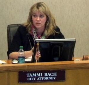 Even though the city does not have a customary use beach ordinance, Fernandina Beach City Attorney Tammi Bach wrote, “HB 631 is not going to affect the City since private property south of Main Beach only extend to the toe of the primary dune. Private properties north of Main Beach and east of Ocean Avenue have either executed voluntary easement agreements with the City for beach renourishment or have easements established in favor of the City via eminent domain actions filed by Jacobs & Associates in 2004-2007. Therefore, there is no dry sand that I know of in the City that is not City owned.”
HB 631 was one of many proposed this year that would allow the state to override local governments’ authority to tailor policies to meet the needs of their own communities, which might differ significantly from those of other communities around the state. Many of those so-termed “preemption” efforts went down in defeat. But HB631 survived and has become law. The new law forces those local governments that are not protected by a customary use ordinance or other means (as in Fernandina Beach) to mount a legal challenge to decide if the public can access private beach property in their jurisdictions above the mean high water line for recreational purposes.
Beach goers and beach communities around the state have raised alarms over what they see as a triumph for private property rights over the historical and traditional view that Florida’s beaches belong to all the people, not just the few who can afford beachfront property.
No man’s life, liberty or property is safe while the legislature is in session. —Author unknown


Thanks for explaining how this will affect city beach property. What about the county beach areas?
County is trying to decide on a course of action. Suggest you attend or watch the BOCC meeting on April 18 for more info.
What about county beach??
County is trying to decide on a course of action. Suggest you attend or watch the BOCC meeting on April 18 for more info.
This article states: “Even though the city does not have a customary use beach ordinance, Fernandina Beach City Attorney Tammi Bach wrote, ‘HB 631 is not going to affect the City since private property south of Main Beach only extend to the toe of the primary dune’.”
I don’t believe Ms. Bach’s statement is totally correct regarding private property ownership versus City easements.
The “Perpetual Beach Storm Damage Reduction Easement” prepared by Jacobs & Associates for the City in early-2004 and sent to beachfront property owners (at least those south of Main Beach) contains the following wording in the legal description of the east boundary of all properties for which City demanded owners execute said easement: “That portion of the property described as the ‘Legal Description’ that is landward of the Erosion Control Line and seaward of any rock revetment, dune, or the seawardmost occurrence of the +12-ft NGVD-1929 contour on the property, whichever is more landward.”
I suspect, but cannot confirm, that there are many areas along Amelia Island’s city beaches where the +12-ft NGVD-1929 contour will be landward of the “toe of the primary dune” and thus under City control via these easements.
My apologies regarding my earlier reply . . . I should have clarified for readers what term “+12-ft NGVD-1929 contour” means. This term refers to a geographic datum (a wavering line defined by connected points of geographic latitude and longitude) that was establish by classical surveying techniques and references where the ground contour at that time contacted an elevation that is 12 feet above the Mean Sea Level datum established in 1929. The NGVD abbreviation stands for National Geodetic Vertical Datum.
My understanding is that the +12-ft NGVD-1929 contour is fixed in latitude and longitude and fixed in altitude above a 1929 Mean Sea Level reference surface and thus will not vary with time despite beach erosion or buildup, ground uplift or subsidence, or increasing geodetic sea level.
Finally, months later, a fact based response in regards to the City of Fernandina Beach.
Though because hurricane storms can change our coastline, and where platted property lines lay in relation to dry sand, wouldn’t it be prudent for the City to enact a public use statute, pre-empting future lawsuits?
Now what about the rest of the island, the County beaches???? Aren’t these at risk?