Submitted by Suanne Z. Thamm
Reporter – News Analyst
August 9, 2019 – noon
One of the tasks assigned to City Manager Martin by the Fernandina Beach City Commission (FBCC) at its Visioning Session on February 9, 2019, was to present a proposed concept relating to the City Waterfront by August 6, 2019. Martin presented the concept at the August 6, 2019 FBCC Regular Meeting. Although the item was not billed as an action item, by declaring the adoption of the plan an emergency, the FBCC added it to the agenda and passed the recommendation with amendment on a unanimous vote.
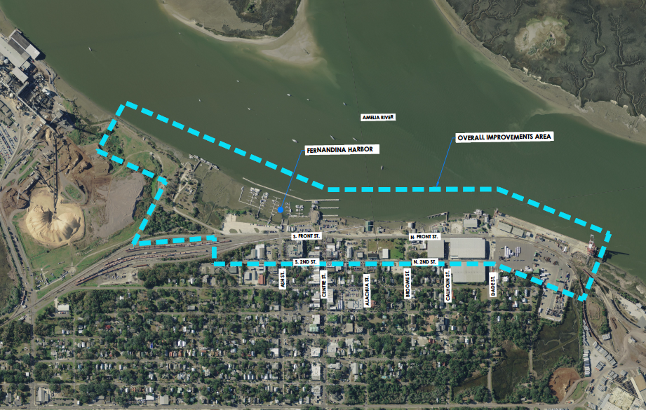
The plan as presented designated the placement of park areas but did not contain park details. Martin said that his call for public input to the plan resulted in emails from citizens asking for open areas that could be used for many functions. Public reaction was that people do not need artificial enhancements to draw them to the waterfront. The waterfront area was defined as extending from Rayonier Advanced Material on the south to the Port of Fernandina on the north and westward to Second Street. The park area is located west of the railroad tracks between the Port and Atlantic Seafood.
Martin credited Passero Associates with helping with the graphics and local resident Eric Bartelt for helping with the concepts. He said that what he was presenting did not differ significantly from the last FBCC approved plan in 2012. Martin said that the challenge is presented by the configuration of Front Street, which does not leave much room between the street and the Amelia River. Areas marked in green on the maps indicate where work needs to be done.
FDOT is willing to construct and pay for new safety crossings at Ash and Centre Streets. The city will need to pay for the new crossing at Alachua Street.

The plan calls for a new Atlantic Seafood Building and additional retail space to the left of that building. Martin said that these commercial ventures could in theory provide additional financial support for the marina operation. He said that he has been working with an interested partner in developing that site, and that a briefing will be provided to the Marina Advisory Board in October.
The plan also highlights the proposed sidewalk and fence on the east side of the railroad tracks. The plan has been approved by the railroad and the city has allocated funding. The central part of the plan calls for increased green space and a reduction in parking. Martin reiterated the public consensus for open space in this area, similar to Kissimmee, Beaufort SC and St. Marys. The area would support a farmers market, a portable stage and concerts. Electrical service in the area has been upgraded to provide for support for community events at the direction of the commission.

In order to address railroad safety concerns, the Veterans Monument and Front Street will need to be shifted slightly westward. The Amelia River ticket booth remains in place.
The cross hatched area on the map below represents the city owned building (101 N. Front Street) that was recently demolished. A circular roundabout was added to facilitate traffic flow and to maintain 2-way traffic on Front Street. The Alachua rail crossing remains a work in progress, since the original design called for one-way traffic on Front Street. Martin expressed confidence that the design could be changed to accommodate 2-way traffic and still fit in the area.

The plan contemplates the city’s acquisition of the remaining privately owned land parcel west of the railroad between Centre and Alachua Streets.
Martin advised the commission that he had a proposal from an engineering firm on the city’s approved list for $20K to conceptually redesign Front Street and provide cost estimates for construction. Money for such work is comprehended in the current years Capital Improvement Fund.
Martin said that relocation of Atlantic Seafood will be required as part of the city’s Stormwater Plan. It will be up to the current lessee, who will be given first option, whether he is interested in working with the city on this.
Commission Discussion
Vice Mayor Len Kreger reminded commissioners that the other parks cited by the public “are not just football fields” but include swings and other enhancements.
Commissioner Chip Ross supported the plan as a good beginning. He said that the city is currently having the shoreline designed by Passero Associates and that it is good to settle the location of Front Street before proceeding with further park design. Questions of land use can be resolved after the eastern and western perimeters are established. He supported the City Manager’s request to move forward with engineering design for Front Street.
Commissioner Phil Chapman expressed concerns about the ability of the current boat ramp to support the larger boats and trailers.
Commissioner Mike Lednovich also expressed support for moving forward with the engineering contract. He said he liked what he has heard but wondered what the next step would be.
Martin said that once the landward and seaward boundaries are set, the city will proceed to seek grants for additional work and ask the railroad to commence work on the crossings that FDOT is financing.
Lednovich asked further questions about proceeding with park design. Ross expressed his belief that park design could not proceed without having the park boundaries established. He said, “Those are the two pieces of bread in the sandwich. The filling can wait until we have those two pieces of bread.” He suggested that it would take 6-8 months for engineering designs to be completed.
“The plan cannot proceed as laid out,” Ross said, “without the acquisition of the piece of private property sitting between the city owned parcels.”
Lednovich supported public discussion of what should be included in the park. “I don’t want to lose 6-9 months,” he said. “We’ve been wondering where this park is for 25 years.”
Kreger said at this point he believed it was critical to adopt the basic plan in order to proceed with acquisition of the private property needed for the design.

Ross suggested that the Parks and Recreation Committee be charged with developing the plan Lednovich called for. Miller recapped all the meetings that have been held over the years to date that led to development of a plan in 2012. He called upon Eric Bartelt, who has been extensively involved in waterfront park planning to comment.
Bartelt allowed that with the passage of time and creation of other city parks with various amenities, plans for things like playgrounds need to be reexamined. Bartelt said that some changes would be needed but that planning could continue.
Kreger supported the call for more citizen input, but stressed that the need to approve the footprint was imperative now.
Lednovich agreed that the park plan could go to the Parks and Recreation Committee, but that he wanted a plan for the park itself within 6 months for FBCC consideration. Ross asked that the City Manager come back with a plan at the next meeting, so that the FBCC does not make a decision on the fly. Martin suggested that an appropriate time to consider the plan would be at the FBCC Visioning Session in January, which is five months away.
Commissioner Phil Chapman expressed his desire to move quickly on the final plan presented. He said, “Before you know it, three seats on this Commission could change [a reference to the 2020 General Election]. I want to see enough progress that whoever takes my seat will say, we have got to keep going. We’ve already put so much money into it, we’re at the point of no return. If we’re not there by the time this seat changes, the plan may go back to collecting dust on the shelf.”
The commission took emergency action to approve the footprint plan put forth by the City Manager. The motion also included direction that the Parks and Recreation Committee immediately begin work on a final plan. Ross asked to amend the plan to take the plan all the way south to Parking Lots C and D. His amendment was included in the unanimous vote of approval.

In separate action, the FBCC unanimously approved Resolution 2019-129 which authorized the City Attorney and the City Manager to utilize the services of Jacobs Sholz & Wyler LLC to represent the city in an eminent domain action to acquire certain property along North Front Street (Parcel # 00-00-31-1760- 0001-0020) necessary to complete the proposed waterfront park.
The city has already obtained two estimates on the property.


While approving the footprint is a marginal step forward, the utilization plan for the area promoted by the City Manager goes against the desires expressed by the community in a series of charettes that led to the Commission’s approval of a conceptual plan in 2008 and modified plan in 2012. The concept of the retail space building was first raised in 2005 and soundly rejected by the community in the subsequent charettes. Citizens wanted to protect the view corridors from Ash Street and also believed the City should not be in the business of providing subsidized retail space and competing against private landowners. While there might be some legal obligations to Atlantic Seafood in the current contract, the location of a new facility is entirely up to the City. How about locating it at the now city owned Venturo property? The Riverfront Park represents the only city park west of 8th Street and can serve as a dynamic draw in further supporting the downtown merchants. As to the CM’s claim of no need for “artificial enhancements” but citing St. Mary’s and Beaufort SC – those parks have plenty of enhancements. Beaufort has a large pavilion suitable for musical performances and wedding ceremonies, as well as a large children’s playground, a small cafe building with outside seating, numerous arbor covered swings and seating overlooking the river and so on. The park needs these additional features to serve as a drawing point throughout the day and the year and not just open areas for watching sunsets. The approved plan called for a splash fountain and playground, restrooms and some passive areas. The southern part of Lot C and Lot D remained open space for larger activities such as concerts, movie night, etc. The development can be completed in stages.
One other main difference is that the uplands of the city owned property have always been considered separate from the marina and the domain of the Parks & Recreation department with operating expenses for such to come from the General Fund. To cherrypick parts of the upland area to support the expenses of the marina creates a slippery slope.
I have been a vocal advocate for the riverfront park for 15+ years and served on the original FL Waterfronts Partnership Committee as well as the various city committees that ended up producing the 2008 conceptual and 2012 design plan. Those plans had involvement in their creation by a large number and diverse group of stakeholders. Understandably some factors such as the Alachua crossing will have impacted the plan, but to radically change the functionality of the park is a huge disservice to the community and should not be done.
Will this exaggerate the parking problem? Looks they’re proposing to eliminate 60 spots from the Centre Street area and move 50 of them north to Alachua. At least the young and able bodied will be able to sit in the grass and gaze fondly at the river. The old and infirm can ride downtown, look from their car windows and then go home. I used to love to go downtown, but it’s gotten really hard to walk from the parking places I can find to Brett’s Waterway Café and The Marina Restaurant. If I’m reading this plan correctly, that means no more trips to those places instead of the few I’m already down to. While I agree there may be plenty of places within seven blocks, seven blocks on un-level sidewalks can be hard for an old person.
Nice to see the city making progress. Kudos to Eric Bartelt for helping us move forward!
After so many years, I’ll take forward progress over nit-picking. Would love to see a more comprehensive plan – wondering what the public-private partnership might yield. . .
Nevertheless any progress is a step in the right direction.
green space is all that waterfront has ever needed with maybe some picnic type tables & benches + some parking——–carnival atmosphere with shops playground equipment & razzle dazzle destroy the peaceful relaxed atmosphere of a waterfront park