Submitted by Suanne Z. Thamm
Reporter – News Analyst
February 21, 2019
[NOTE: This morning (February 21, 2019) the City of Fernandina Beach issued a stop work order due to the unresolved conflict between the FLUM and Zoning Maps for the Amelia Bluff project located on Citrona Drive. This action was taken following an email request from the Board of Directors of the Amelia Tree Conservancy, also dated this morning.]
The controversy over developing the upland portion of former School Board property to create the Amelia Bluff subdivision on Citrona Drive once again surfaced at this week’s City Commission meeting.
Fernandina Beach City Commission (FBCC) Chambers at City Hall were filled to capacity and then some with conservationists who had come to the February 19, 2019 meeting to oppose passage of Ordinance 2019-08 on First Reading. This ordinance proposed amending the Future Land Use Map (FLUM) to change approximately 6.40 acres of land from Conservation (CON) to Low Density Residential (LDR). This property was specifically identified as CON in previous staff reports, and the purchaser/developer relied on staff supposition that such classification would not be a hinderance to development because of a “mapping error”.
In the summary that accompanied the ordinance, City Attorney Tammi Bach wrote:
“It appears that City staff represented to the developer that the Conservation Future Land Use on the subject property is a “mapping error” because the wetland map layer from the Nassau County Property Appraiser website (Map Layers tab) shows the wetlands are located north and east of the subject property that is proposed for residential development. The St. Johns River Water Management District (SJRWMD) provides the wetland maps to the Nassau County Property Appraiser and local governments (i.e. City, County). The term “scrivener’s error” underestimates the impact of this “mapping error” since the City takes conservation very seriously, and City staff would not represent that residential development should occur on wetlands. It appears from aerial photography, topographic maps and SJRWMD maps that the subject property is located at higher elevations that the wetlands to the east; therefore, a FLUM change from Conservation to Residential is consistent with the Comprehensive Plan and Land Development Code.”

Following more than 1.5 hours of presentation, input from 10 speakers and discussion, commissioners voted 3-2 to approve the ordinance. Both commissioners Mike Lednovich and Chip Ross strenuously opposed approval, citing that they campaigned on a platform to support strong conservation efforts. Vice Mayor Len Kreger supported the measure, agreeing that the dispute was created by a mapping error. Commissioner Phil Chapman suggested that the city would be better able to further its goal of acquiring land for conservation by spending limited funds to purchase other environmentally sensitive land, as opposed to buying back the land in question and restoring it to its natural state. Mayor John Miller supported the ordinance, but indicated that he was subject to changing his opinion based upon additional information provided at Second Reading.
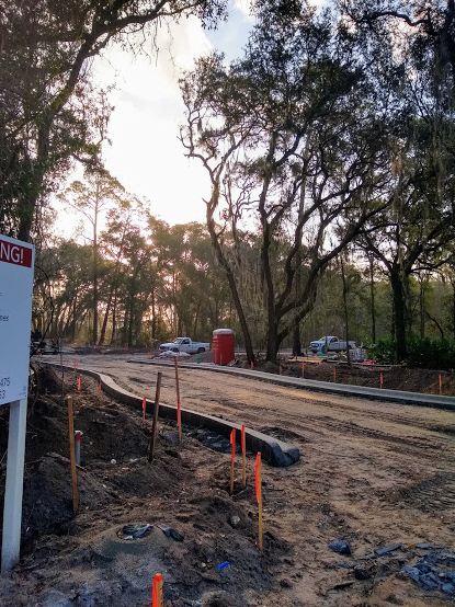
Construction is already underway on the subject property, which is located on the east side of Citrona Drive across from Fernandina Beach High School and adjacent to the Shell Cove development. Plans call for building 30 single family homes on the 10 acres of upland property. According to developer Wirt Beard, representing W.R. Howell Company, seven families have already purchased home sites.
Background
The city of Fernandina Beach has been working with the Nassau County School District and the developer over the past two years to resolve issues relating to the vacation of the portion of Gum Street on the property. The property, previously owned by the School District for the purpose of expanding school buildings and maintenance facilities, had been declared surplus. The School District did not approach to city to determine its interest in purchasing the land. Rather, they advertised it for sale and it was purchased by developer Wirt Beard with the proviso that the Gum Street right-of-way (ROW) be vacated.
The city, the School Board and the developer ultimately entered into agreement via a Memorandum Of Understanding (MOU) in August 2017, which was approved as Resolution 2017-123. Under that agreement: all jurisdictional wetlands on the property were transferred to the city and set aside as conservation land; FDOT agreed to transfer clear title to the city to two contiguous parcels on Egans Creek to provide access to the Greenway; and the developer agreed to donate $115,000 to the city for land conservation purposes upon final plat approval.
The wetlands portion of the property totaling 3.63 acres of land was transferred to the City of Fernandina through a quit claim deed on March 20, 2018 (Resolution 2018-39). Access to the abutting properties under ownership of the Florida Department of Transportation and located on the eastern edge of the property was established through the creation of a public right-of-way under Resolution 2018-40 on March 20, 2018.
At the May 1, 2018 Regular FBCC Meeting, city staff reported that the developer had fulfilled the requirements of the MOU and was requesting approval of the subdivision as designed to meet or exceed standards of the Low Density Residential land use category and R-1 zoning district and applicable LDC policies. Part of this approval involved a tree survey and creation of two dry retention ponds.
No member of the public spoke to this agenda item at that time.
The FBCC approved on a 4-1 vote (Commissioner Ross dissenting) the preliminary plat for the Amelia Bluff development.
The city issued permits, and work is underway to clear land, provide infrastructure and sell homes.
Current controversy
The city’s Planning Advisory Board member Frank Santry in November 2018 discovered a discrepancy in mapping. He claimed that the Amelia Bluff property has been designated “Conservation” on official city maps. City Planning Manager Kelly Gibson explained to the FBCC the history of the property, asserting that the designation “conservation” for the entire parcel was the result of a mapping error.
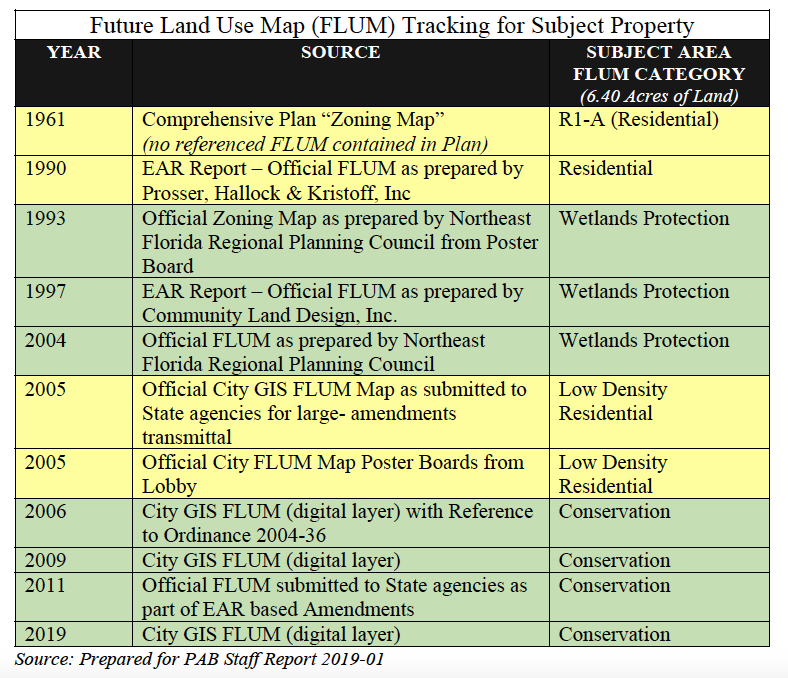

She and city planner Jacob Platt presented a series of topographic and land use maps to the FBCC at their February 19, 2019 Regular Meeting revealing the existence of a bluff and a 12-foot drop off to a wetlands area that the developer had agreed to designate as wetlands. However, the 10-acre uplands portion of the property, according to city staff, had not been designated “conservation.”
Wirt Beard, representing W.R. Howell, said that relying on assurances from city staff, his company had broken ground on the new 30-house development in August 2018. Work is well underway to provide infrastructure needs for the development. Streets are being poured this week.
Public input

Ten speakers objected to the city’s plan to approve a small scale land use amendment to correct what the city determined was a mapping error. Speakers disagreed to one degree or another with staff’s conclusions that the discrepancy was a mapping error. One speaker urged commissioners to “man up and hold the line” on development in environmentally sensitive areas. Others claimed that the FLUM trumped the zoning map, which indicated that the portion of the area underdevelopment was low density residential. Some suggested that the city take back the land from the developer and restore it to its natural state. At this suggestion, City Attorney Tammi Bach cautioned that there were federal and state laws governing the taking of private property.
Commissioner discussion

Following public input, Commissioner Mike Lednovich quizzed PAB member Frank Santry on Santry’s discovery of the discrepancy in November 2018. Santry said that at every prior step in the approval process staff had certified that the plans were consistent with the city’s Comprehensive Plan. Santry said that the city may not approve residential development on conservation land.
Vice Mayor Len Kreger said he was convinced that the problem was the result of a mapping error. He said that staff and the PAB as the Local Planning Agency should have identified this earlier. “The Commission should have caught this, too, in theory,” Kreger said. Kreger reminded the audience that the land had been designated for school construction while owned by the School District. He agreed that the discovery presented a dilemma, but that he would recommend approval of the change.
 After seconding Kreger’s motion, Commissioner Phil Chapman reminded the audience that prior to his election he had publicly opposed the city’s giving away the Gum Street ROW, which had begun following the School District’s sale of the property to the developer. “We can sit here and point fingers; we can play Monday morning quarterback,” Chapman said. “But one of the questions becomes: how much “conservation money” do you want to spend to stand on principle, to buy back this land, which will prevent us from buying other conservation land? It becomes a question of dollars and cents. So we have to give them $2M. That’s $2M of other properties that we could buy, without mistakes. Trust me: I drive past that development every day. I do not like that development. But I try to look at problems logically. … We got knocked down, we made a mistake. But the question is: how much are you willing to spend for this? I don’t see it. Let’s move forward and spend the money on other conservation land, because that’s what the citizens want.”

Commissioner Chip Ross disputed Chapman’s claim that it would cost $2M to buy the land back, believing that it would cost substantially less. He allowed that no one had real figures to discuss. According to Ross, the real issue was to maintain the land in conservation. He quoted a previous speaker who had said that fixing the land would be expensive, but maintaining it as conservation was priceless. “It’s an expensive lesson,” he said, “but maybe the city needs to learn a lesson.” He added, “We made a commitment to preserve conservation land, and this is conservation land; we made a commitment to purchase conservation land, and this is conservation land.”

Commissioner Mike Lednovich reminded commissioners and the audience that during his recent campaign he had promised never to change the FLUM into residential property. “I’m going to keep that promise,” he asserted. He expressed concerns over what he fears to be efforts to pave over the island to build houses and hotels at the expense of the island’s unique maritime forest. “In 2011 with adoption of the current FLUM, we defined what our island is supposed to be,” he said. “And it is the law. Are my fellow commissioners going to thumb their noses at the law?”

Wirt Beard made a final appearance before the FBCC. He said, “It’s very awkward to be standing here with an approved set of plans and infrastructure already in the ground.” He said there has been no conversation outside the meeting about the city’s buying back the land. “We intend to complete the development and sell lots to the builder. I don’t know where this talk of our selling back the land has originated. We hope to see the mapping error corrected so we can move forward.”
City Attorney Tammi Bach reminded the audience and commission that in March the city would enact a moratorium on Future Land Use Map Amendments in order to fix inconsistencies between the FLUM and zoning maps.

Mayor John Miller said that philosophically he agreed with everything that every commissioner had articulated during the discussion. He said that he has always agreed that the city needs to preserve all the green space that it can. “At the same time,” Miller said, “we need to be fair. I don’t think it would be fair to treat this developer differently because of something that the city did wrong.” While agreeing to support the measure on first reading, Miller said that he remained open to considering new evidence that the entire area was intended to remain conservation, as opposed to the portion designated wetlands.
Ross added comments about fairness, and whether the decision needed to be fair to the developer or the community.
Lednovich said, “The developer did nothing wrong here. He relied on advice from city staff. He was misled; that’s a tragedy.” He directed his remarks toward the audience. “For the next meeting get 10 friends to join you. Email the city manager to let him know how many people are going to attend, so if we have to move the meeting to the Atlantic Rec center to accommodate everybody. Your voice, your outrage will change this vote. Please rally.”

Chapman expressed a desire to get additional information from staff before the second reading (probably March 19) regarding the cost to leave things as they are or to return the land to conservation. “Costs weigh heavily on my mind,” he said. “We have a bunch of change orders for the marina that will probably continue. We have had many people ask us to purchase other land parcels for conservation.” He said if someone can convince him that it will only cost $100K to restore the land in question, he would change his vote. “But if someone is going to come in and say that it is going to cost several million dollars, I’m going to have a hard time with that. We sit up here supposedly to protect the interests of the entire island. And that includes being able to upgrade our buildings, which are falling down. … There are a lot of issues in this town and unfortunately it comes down to the dollars. Those projects are reflected in your tax bill.”
Miller asked the City Attorney what would happen if the FBCC failed to approve the proposed land use amendment. She said that failure to approve it would mean that the developer would not be able to get any more permits for clearing or construction on the land. “At that point, it would be in the developer’s hands as to how they wanted to proceed, if they wanted to make a claim against the city,” she said. Mediation could follow or a law suit. If the city prevailed and assumed ownership, it could rip out the infrastructure and plant trees.
The ordinance passed 3-2 on First Reading, with both Lednovich and Ross in opposition.
At this time, it appears that the Second Reading of the ordinance will take place on March 19, 2019.


Good call on the Stop Work until this matter can be fully dissected, including future costs and ramifications associated with any action. A construction delay is nothing compared to the decimation and loss of the maritime canopy and hammocks here. Never should have gotten this far and unfortunate already.
The city made a mistake…the developer is in the right and will prevail in court based on well established precedent. Take the city to task not the developer…hopefully someone will scrub the planning docs before this “error” happens again.
Perhaps. But caveat emptor. With such a large investment one should not rely on “assurances” that there was an error that will be fixed.
This discrepancy- regardless of fault- should have been untangled before the first shovel hit the dirt. Actually before the first line was drawn on a plan, so perhaps a conservation bluff could become a centerpiece.
So glad to see a Stop Work on this property. Never should have gotten this far. Conserve the area and the canopy.
We have to fight to preserve and conserve the island’s canopy which is disappearing at an alarming rate. If we care, we need to show up March 19th–the 2nd reading and be heard!
Subsequent to the meeting, Commissioner Lednovich requested the City Attorney and the City Manager to issue a stop work order at the Amelia Bluff development. Commissioner Lednovich should be commended for requesting this action and being a steward of the Public Interest in this matter.
Thank you Commissioner Lednovich.
Some properties were re-zoned along the greenway and later found to have been changed in error. The bluff and wetland delineation line would be dramatic on the Amelia Bluff site.
I am sure I will be blasted for this…The city made a mistake..the city will have to eat whatever dollars it cost to buy the property back or let it happen….What I find funny is many of the people not for changing the designation are newbies to the island…In particular the ones sitting on the board..I am by no means suggesting we take every tree on the island down…However the attitude of the newbies are a little over the top…Maybe some of the new folks in there new communities can donate there homes to the city to be razed and be used as conservation land…? That would be a good place to start.
Pave paradise and put up a parking lot. Once it’s gone, it’s gone forever!!!
The problem for me is a pattern of capitulation to development and the “well it’s too late now. Next time we will prevent this” attitude. I feel already pushed too far in this direction and want this stopped now!
I also question the sincerity of the developer as being the victim of city assurances. Are you telling me a multi million dollar project did not have the benefit of legal scrutiny, advising them of the risk of proceeding without written documentation of the properties eligibility for construction?
Also, how did our officials proceed for years processing this without recognizing and flagging this violation of the FLUM? Who do these people report to, and what are the consequences of this incompetence?
Mr. Miller: I agree with you on questioning “consequences”.
The three “yes” votes on this first reading were justified to a “mapping error” (which could have been procedurally corrected at various stages over the last two years as the transaction flowed through the review and permitting processes). However, those “yes” votes undercut another aspect of this situation which is critical, inexcusable, and has resulted in the current level of community anger and distrust of City processes and staff as demonstrated at the commission meeting and subsequent social media.
This problem is the result of an egregious lack of candor and concealment by City staff to the various volunteer decision makers involved.
These decision makers/committee members assume their functions and forfeit precious personal time believing their commitment will improve our community. It is very second-rate to learn that City staff had no problem with providing them inaccurate information, trusting that the City Commission eventually would it “make it right”.
Christine:
Actually, the mayor’s position was that it would be “unfair to the developer” to punish him for the city’s errors. I believe the mayor needs to concern himself with what is unfair to us, his employers.
Cleaning house is also important since numerous individuals must be complicit in pretending the Conservation designation on the FLUM did not exist.
Hopefully we can save the land as part of the Greenway buffer, and clean up the City’s act!
Michael
I salute Suanne Thann for a marvelous piece of journalism. It is rare today to find coverage of an issue that is so thorough, unbiased, documented, and well written. You are a credit to the field of journalism!
I agree!!