Submitted by Suanne Z. Thamm
Reporter – News Analyst
March 12, 2018 9:00 a.m.
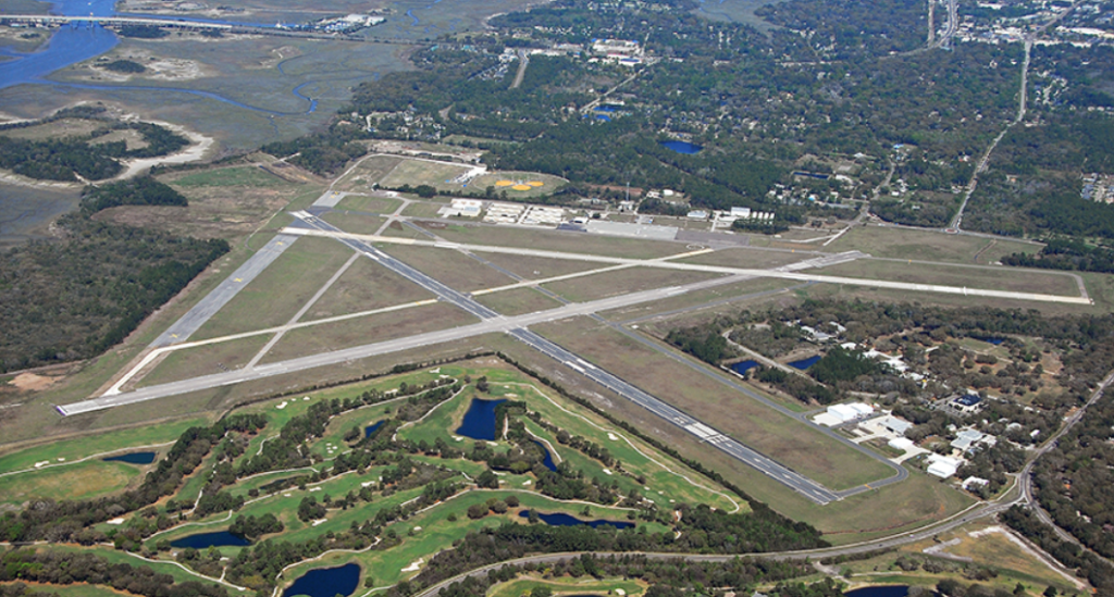
For more than 75 years there has been an airport on Amelia Island. And for 71 of those years, the airport has belonged to the city of Fernandina Beach, FL. Situated on the marsh side of the island, this general aviation airport has had a colorful history involving the United States Navy and World War II. Over time, it has transformed itself from what at one point appeared to be almost a private club for local aviators into a safe and modern facility able to host today’s corporate jet traffic.
The Fernandina Beach Municipal Airport (FBMA) is now poised for the next stage in its history. Effective April 1, 2018, Bent Wing Flight Services will begin operation as the airport’s new Fixed Base Operator (FBO), following 20 years of services provided by McGill Aviation.
After years of debate, grants writing, and local political wrangling, the city will dedicate a new terminal/welcome center at the airport this summer to accommodate both city operations and the FBO. The building will also house exhibits and meeting space along with a public viewing area, making the airport more accessible to the community as well as visitors.
And that’s not all. The plans for the new terminal also recommended outdoor exhibits to provide educational experiences for students interested in aviation and a Quonset hut that could be used as meeting space. While these additions will probably require more time to be added to the FBMA, the Friends of Fernandina Aviation (FOFA) continue to work with the city and the new FBO to ensure that the Fernandina Airport is a valuable asset to the city and the local community.
The summary history below was drawn from information included in various city documents, including: History of the City of Fernandina Beach Municipal Airport – Golf Course, 1942-1992, written by Anne Montgomery and Robert Gulick on behalf of the Financial Advisory Committee in August 1992; Development History of the Fernandina Beach Municipal Airport [undated]; Airport Master Plan Update prepared by Passero Associates, Inc. in September 2015.
Earliest history
In 1942 the U.S. Government made a proposal to the City of Fernandina: If the city could provide sufficient lands, the U.S. Navy and the Civil Aeronautics Administration (CAA) were willing to invest $900,000 to develop a Class 4 Airport as an adjunct to the Mayport and Jacksonville Naval Air Bases for the purpose of training Navy Corsair fighter pilots. The City Commission liked that idea. The city assembled over 1230 acres of farmland with purchases totaling $15,000 (authorized from the Capital Fund) from Dr. D.G. Humphries, the estate of Louis G. Hirth and some smaller parcels.

On May 26, 1943 the city entered into a lease with the U.S. Government to provide 1,116 acres of land to the U.S. Navy to build an airport with four runways. There was no payment to the city for the use of the land. The Nassau County Board of County Commissioners expended available gasoline tax monies to relocate what was known as the Amelia City Road to accommodate the airport.
At the end of World War II, the U.S. Government determined that they no longer needed this airport or the land. The U.S. War Assets Administration signed over to the City of Fernandina cancellation of the lease and Quitclaim Deed. While no monetary restrictions were stated, there were five restrictions running with the land:
- The airport will be available for public use;
- The entire landing area, structures and equipment shall be maintained in good and serviceable condition during their estimated life (as determined by the CAA);
- The lands may be transferred with CAA approval;
- Certain building limits are restricted as may be hazardous and interfere with efficient operations;
- That the government shall have the right to use the airport in common with others.
On July 10, 1947, 1,116 acres along with all buildings and improvements were transferred to the city. The deed of release signed by the General Services Administration on November 29, 1949 placed an additional condition on the transfer: proceeds of the sale of any of the property “shall be used for the operation, maintenance or development of the airport.”

The 1950’s and 1960’s
In 1951 the city of Fernandina and the Town of Fernandina Beach consolidated into what became the City of Fernandina Beach. Although now in possession of an airport, the city made little use of the facility.
In 1954, the city determined that it was in their long-term interest to release certain parcels of airport land from the quitclaim restrictions in anticipation of improved commercial opportunity. Five separate parcels were released (approximately 596 acres) on December 8, 1954. But the land was never sold or developed and remained airport land.
Between 1954-1966, the airport was largely unattended. Its use as an airport was very limited due to minimal maintenance that resulted in all but two of the approaches having natural hazards.
According to a history prepared by the city’s Financial Advisory Committee in 1992, the airport was classified as an Enterprise Fund from its inception. But the “Airport Fund” per se was first mentioned in City Budgets for 1963-64.
In 1966, Smith & Gillespie Engineers prepared the first Airport Property and Master Plan to further develop the airport. That document designated areas for airport use and those to be used for non-airport use, including a golf course, a residential subdivision and an industrial park. Rock, the first Fixed Base Operator (FBO) was hired. Although the contract with Rock was for 7 years, it only lasted one year.
The city began meeting with the Federal Aviation Authority (FAA) in fall 1966 to discuss the Master Plan and to secure release of restrictions for the development of residential streets, sewers and improvements with revenue from the sale of lots east of Amelia Road. There seemed to be a misunderstanding of intent between the city and the FAA office in Miami that was finally resolved at the Washington level.
Finally Max Bard, FAA ‘s representative in Miami, stated that “he would process and recommend the approval at the Washington level, a request by the City, for release to it of all the present airport property lying east of Amelia Road with the exception of that land lying under two runway clear zones: northeast of the northeast end of the northeast/southwest runway and east of the east end of the northeast runway with easements granted to the City for the use of the land lying under these clear zones for golf course and roadway purposes.” The only restrictions on the use of the remaining portion of the released parcel were height of structures and acceptance of high noise level in the air.
Bard noted that the city was in a fortunate position due to the type of agreement (an AP4) it originally entered into with the federal government. Thanks to that agreement, “the FAA could not hold the City to the stipulation of plowing profits from the non-aviation development of the released area back into maintenance and development of the airfield facility.”
As a result of the 1966 FAA decisions, the city began to re-establish the airport property based upon “modern operational requirements” and to boot strap the cost of the development of the golf course area east of Amelia Road. Bard added, “Further, the City is agreeable that net proceeds over the duration of the development period will be used on the airport side of the highway, as needed to develop the facilities.”
On April 5, 1968, the FAA approved the Master Plan. That plan established that all land west of today’s Amelia Parkway and Buccaneer Trail be returned to the airport, and that all land east of that road be released to the city for residential development, access road purposes and expansion of the city golf course. However, it was noted that land under the approaches of Runways 22, 26 (now 27) and 30 (now 31) in the clear zone were not released, but that an easement granted for the land to be used for a golf course only and clear zones must be kept clear. That land was never released as airport land.
The 1970’s and 1980’s
Piasecki Aircraft Corporation obtained a ten-year lease from the city in 1970 to serve as the airport’s FBO. Under the terms of the lease it appears that the FBO agreed to pay the city $100 per month for each of three parcels and to pay the city one cent per gallon of fuel sold for the first ten years and two cents per gallon for the second ten years.
The Amelia Island Company leased and/or purchased land within the airport property and airport released property in the early 1970’s.
Fehner, St. John and Associates, Inc. of Orlando developed the second Airport Master Plan for 1975-1995. This plan recommended the creation of an Airport Advisory Board. The Airport Advisory Commission (AAC) was in turn established by Ordinance 671 in 1984 as a 7-member commission.
Runway/taxi lighting was first installed in 1979 to provide the airport nighttime and 24/7 operational capacity.

But there were some hiccups. In 1981 the city sold 2.2 acres previously released from aeronautical use but still Airport land to the Quinn’s for $38,400. But 3 years later the FAA determined that this land was needed for airport development. The city repurchased this land for $44,000 in 1984.
In 1985, the city bought out a contract with another FBO (Hawkins).
In 1986, the first set of six t-hangars was built at the airport. Twelve additional hangars were added in 1989. Also in 1989, S-Tec Corporation built a large corporate hangar on east side of Airport. [In 1995 it was transferred to Black Shadow Aviation.]
In 1988 Rawls Aviation operated the FBO as a private entity. This later became Island Aviation Services (1992). In March 1998 Island Aviation sold the FBO to McGill Aviation. McGill Aviation currently serves as FBO.
The 1990’s

The 1990’s saw increased development and activity at the airport. In 1990, a new Airport Master Plan was developed by Hoyle Tanner and Associates and approved by FAA.
In 1993 National Air Shows built a large corporate hangar. Since 2000 Island Aviation Services, Inc., a maintenance and avionics provider has used that hangar. Twelve more t-hangars were built in 1995, bringing the total number of t-hangars to 30.
In 1995, Runway 13/31 was rehabilitated as a FDOT demonstration project at no cost to the Airport, and in1997 the first instrument approach (GPS) procedure was implemented by the FAA to Runway 13.
March 1998 – Island Aviation Services FBO sells to McGill Aviation FBO.
FDOT in 1998 included funding in its capital improvement plan to fund a new General Aviation terminal at 65% funding.
The airport was connected to city water in 1997, the same year that the process of developing Crane Island began. In late 1998 Royal Amelia Golf Course was approved for construction on airport property, and the Black Shadow corporate hangar facility was transferred to Amelia Island Plantation.
In 1999, another Airport Master Plan Update was completed by Reynolds, Smith and Hill, Inc. and approved by FAA.
Early 2000 years
2000 saw the opening of the Royal Amelia golf course (today: Amelia River Golf Course), built on airport property. Most land had been previously released for non-aeronautical use but not as airport land.
Twelve more t-hangars were added to the airport, six in in 2000 and another six in 2003. Also in 2003, the Airport Advisory Commission brought up the need for more GPS runway approaches.
And in 2003, FDOT proposed to fund a General Aviation terminal building. However, use of the term “terminal” gave rise to fears in the community that there were plans afoot to add scheduled airplane services and larger aircraft to the airport. Although neither fear was founded, the city backed away from pursuing the project owing to unrest among the electorate.
The City Commission voted in 2005 not to move forward with new General Aviation terminal facility, thus rejecting the FDOT offered 65% funding. The result of this decision was that FDOT did not offer any future funding to the airport in its five-year capital improvement plan beginning 2010.
Runway 18/36 permanently closed in 2004. This was the airport’s little used fourth runway, ineligible for grant funding. It had never been updated or repaired since it was originally built in 1944.
Thanks to grant funding, Runway 4/22 was rehabilitated with FAA 95% funding in 2004 and in 2005, Runway 8/26 white-top rehabilitation was completed as a FDOT demonstration project at no cost to the Airport.
In 2004, costly litigation began between the current FBO operator, McGill Aviation, and the city (not the Airport), which was not concluded until 2010.
In July 2005, the Airport Advisory Commission recommended that the city start the process to increase runway approaches. Minutes for 2006 reflect the AAC’s support of improved runway approaches as a key to the success of the airport.
In 2008, an additional ten t-hangars/row hangars were built, bringing the total number of hangars to 52.
The FAA in October 2008 granted the Airport a letter of release to allow 4.9 acres of airport land be sold to Crane Island Developers for $533,000 to provide an access road to Crane Island. This money was used as the Airport’s share to repair Runway 13/31, which had failed under the earlier demonstration project.
On July 2, 2009 the Fernandina Beach Airport identifier was changed from 55J to FHB.
The decade ended in 2009 with construction of two large corporate hangars by Sovereign Corporation, a private entity.
Since 2010

Passero Associates, Inc., the city’s airport consultant completed Airport Layout Plan Revisions in 2010 and 2011, which were approved by the FAA. Note that a revision is an administrative action rather than a long-term plan development of Airport.
The FAA implemented a second instrument approach (GPS) procedure on June 3, 2010 to Runway 22. That same year, Runway 13/31 rehabilitated with 50% FDOT funding.
On January 3, 2012, the FAA granted the Airport a letter of release to allow 8.37 acres of airport land to be sold to Florida Public Utilities for $730,000.
In late 2014 work began on a new Airport Master Plan. This followed a 1999 Planning Study. A Planning Team worked with the Technical Advisory Committee in a series of public meetings over more than ten months to produce the current plan, which was presented to and approved by the Fernandina Beach City Commission in September 2015. That plan, which takes the airport to the year 2035, then went on for final approval from the FAA and FDOT.
Phase 1 is the most critical and spans from the present through 2019. Phases 2-4 span from 2020-2035, and possibly beyond:
- Phase 1, based on affordability, provides new box hangars and other revenue-producing additions in addition to regular airfield improvements.
• Phase 2 creates a modified taxiway around the aircraft parking apron, which provides aircraft parking space and access to additional hangar development.
• Phase 3, based on demand, could extend Runway 4 for aircraft operational efficiency, safety, logistical and noise abatement purposes only. It is the only runway that can ever be extended. The extension would not accommodate a larger category of aircraft (commercial airliners for either freight or passenger use, etc.), and the current weight capacity of the pavement is programmed to be maintained. The master plan update is designed using the Gulfstream G-IV business jet as its design aircraft, which has been using the airport for over 20 years.
• Phase 4 is strictly demand-driven for development, maintains conservation areas, and provides for both aviation and non-aviation usage.
Work is currently underway on a new terminal/welcome center at the airport, which will house both city operations and the new FBO. 8 Flags Aviation will do business as Bent Wing Flight Services when it takes over operations as the Fixed Base Operator (FBO) at the Fernandina Beach Municipal Airport on April 1, 2018. The new FBO chose the name in tribute to the airport’s history, which was built during World War II by the U.S. Navy for training on the Corsair F4U airplane.

Official dedication of the new facility is scheduled for July 2018.
To read more about the debate/discussion over the new airport terminal/welcome center, readers are advised to search the Fernandina Observer, which has been reporting on this topic for the last 5 years.
 Editor’s Note: Suanne Z. Thamm is a native of Chautauqua County, NY, who moved to Fernandina Beach from Alexandria,VA, in 1994. As a long time city resident and city watcher, she provides interesting insight into the many issues that impact our city. We are grateful for Suanne’s many contributions to the Fernandina Observer.


Excellent article.