Message from Danny Hinson
Nassau County Emergency Management Director
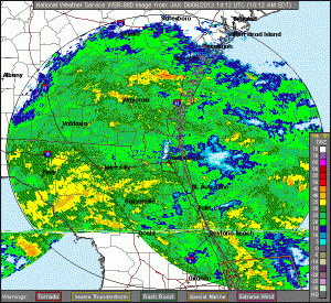
It is anticipated TS Andrea to make landfall near the Florida Big Bend area late today however the impacts of the storm are being felt now. The storm did pick up speed which is good as it will move out of our area rapidly on Friday mid-day. NWS continues to remind us local flooding should be expected with rain bands up until the system passes just to our North and West.
We have another conference call at 11:15 which I will provide updates. If you are asked, sandbags are being made available at Bailey Rd, Mickler Rd and Hilliard Yard. We have pushed this info to our social sites.
If the Sheriff’s Office knows of any road closure please forward that info to EM and Public Works / Road and Bridge Department. We will push any road closure out to social media and our web site. To monitor the NWS web briefing select: http://www.srh.noaa.gov/jax/ look at the top of page for TS Andrea banner.
June 6, 2013 11:06 a.m.